News
Radio occultation observations help studying tropical cyclones
09-11-2020
Tropical cyclones (TCs) are destructive natural phenomena related not only to low pressure systems and extremely strong winds, but also to copious rainfall and dense clouds. TCs cause catastrophic damage to both human lives and health and socioeconomic situation. The economic losses associated with tropical cyclones are rising every year in the USA. Memorable Hurricane Katrina in 2005 caused more than $80 billion damage and killed almost 2 000 people.
Therefore, any technique, which can improve prediction, observation, and modelling tropical cyclones is extremely valuable. One of this techniques is radio-occultation (RO). RO is an active limb viewing technique, which uses the phase and amplitude of two L-band electromagnetic signals transmitted from Global Navigation Satellite System (GNSS) satellites and received by low earth orbit satellites. The Earth’s atmosphere affects the propagating GNSS signal resulting in the signal delay and bending, which eventually can be transformed into high quality meteorological profiles of temperature, pressure, and water vapour using appropriate processing techniques.

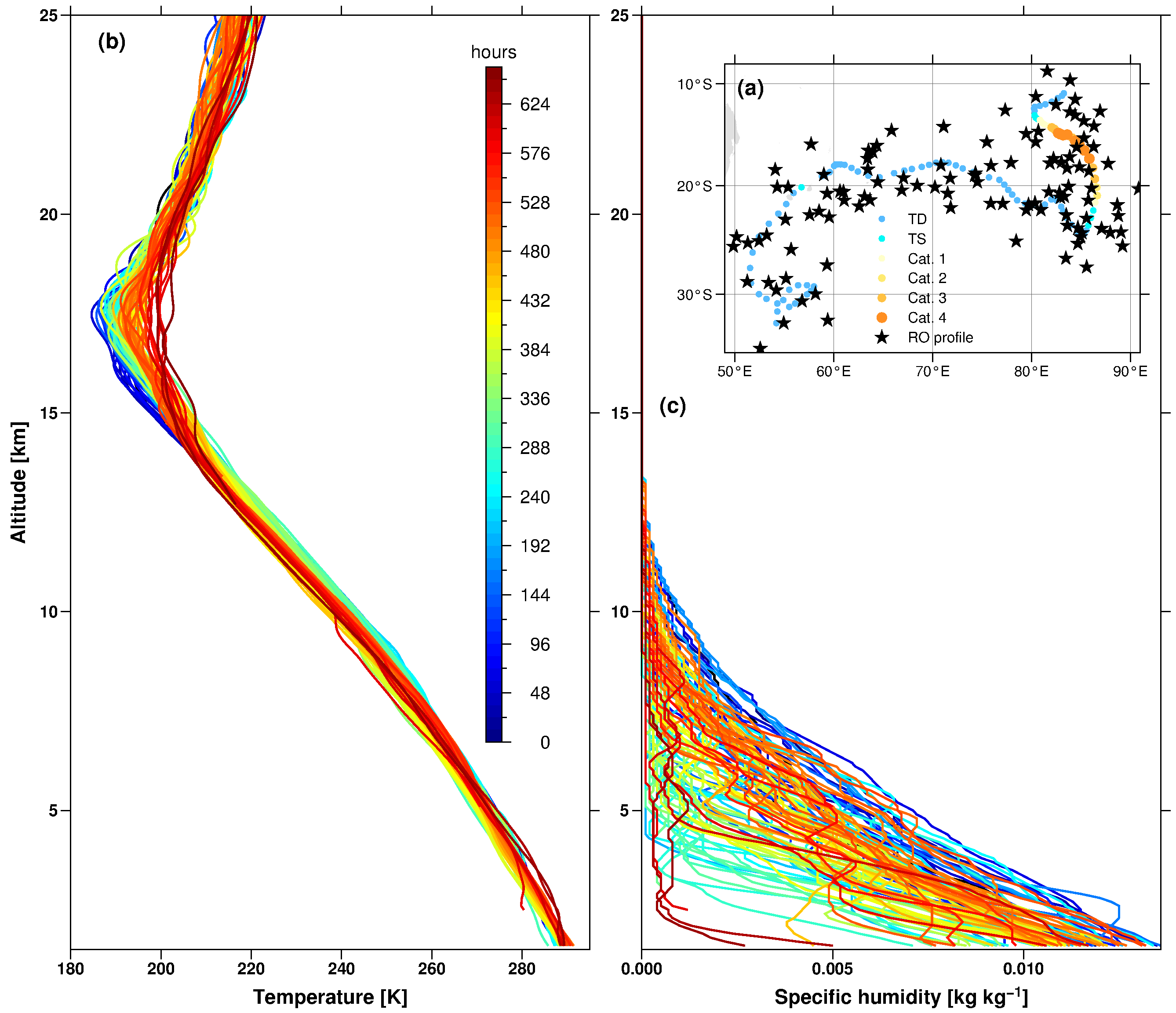
A set of high quality RO profiles during TCs is presented by the team of researchers from the Institute of Geodesy and Geoinformatics at WUELS, the University of Graz, and the University of Padova in their newest work. Observations from over a dozen RO satellite missions were processed and collocated with the TC best tracks in 2001-2018 and eventually collected in a handy archive in the NetCDF files. The final dataset is freely available at:
https://doi.org/10.25364/WEGC/TC-RO1.0:2020.1
The RO-TC record contains information about TC location and intensity, vertical meteorological and climatological RO profiles, and other useful information such as spatial and temporal differences between TC centres and mean tangent points position of the collocated RO profiles. More details on the archive content, application, and study case as well as statistical analyses are demonstrated in the newest issue of Earth System Science Data journal:
Lasota, E., Steiner, A. K., Kirchengast, G. and Biondi, R.: Tropical cyclones vertical structure from GNSS radio occultation: an archive covering the period 2001–2018, Earth Syst. Sci. Data, 12(4), 2679–2693, doi:10.5194/essd-12-2679-2020, 2020.
Therefore, any technique, which can improve prediction, observation, and modelling tropical cyclones is extremely valuable. One of this techniques is radio-occultation (RO). RO is an active limb viewing technique, which uses the phase and amplitude of two L-band electromagnetic signals transmitted from Global Navigation Satellite System (GNSS) satellites and received by low earth orbit satellites. The Earth’s atmosphere affects the propagating GNSS signal resulting in the signal delay and bending, which eventually can be transformed into high quality meteorological profiles of temperature, pressure, and water vapour using appropriate processing techniques.

A set of high quality RO profiles during TCs is presented by the team of researchers from the Institute of Geodesy and Geoinformatics at WUELS, the University of Graz, and the University of Padova in their newest work. Observations from over a dozen RO satellite missions were processed and collocated with the TC best tracks in 2001-2018 and eventually collected in a handy archive in the NetCDF files. The final dataset is freely available at:
https://doi.org/10.25364/WEGC/TC-RO1.0:2020.1
The RO-TC record contains information about TC location and intensity, vertical meteorological and climatological RO profiles, and other useful information such as spatial and temporal differences between TC centres and mean tangent points position of the collocated RO profiles. More details on the archive content, application, and study case as well as statistical analyses are demonstrated in the newest issue of Earth System Science Data journal:
Lasota, E., Steiner, A. K., Kirchengast, G. and Biondi, R.: Tropical cyclones vertical structure from GNSS radio occultation: an archive covering the period 2001–2018, Earth Syst. Sci. Data, 12(4), 2679–2693, doi:10.5194/essd-12-2679-2020, 2020.
 back
back |
 |
 |
 |
Contact
|
INSTITUTE OF GEODESY AND GEOINFORMATICS
Wroclaw University of Environmental and Life Sciences Grunwaldzka 53 50-357 Wroclaw NIP: 896-000-53-54, REGON: 00000 18 67 Phone +48 71 3205617 Fax +48 71 3205617 e-mail: igig@upwr.edu.pl |