News
What have we learned about BeiDou from new laser observations?
29-04-2024
Recent enhancements in global satellite navigation have taken a significant leap forward thanks to the International Laser Ranging Service (ILRS), which now tracks an additional 20 BeiDou-3 satellites orbiting the Earth. This expansion from the initial four satellites under surveillance marks a major milestone for the BeiDou Satellite Navigation System (BDS), a critical component of the global navigation structure alongside GPS and Galileo.
Our team at the Associated ILRS Analysis Center has detailed these advancements in a new study, "Satellite Laser Ranging to BeiDou-3 Satellites: Initial Performance and Contribution to Orbit Model Improvement" by Zajdel et al., 2024. You can read more about the study here: GPS Solutions, Volume 28, 100 (2024). LINK
The BeiDou-3 satellites are equipped with advanced GNSS technology that is set to greatly enhance areas such as geodesy, Earth sciences, and navigation. Despite these advancements, determining precise orbital paths remains a challenge, as different scientific groups often find inaccuracies that could compromise the satellites reliability. To address this, Satellite Laser Ranging (SLR) has become an essential tool. SLR uses laser beams to measure the distance between satellites and ground stations, providing critical external validation of orbit products as determined by different groups. Although these BeiDou-3 satellites have been in orbit for several years, laser tracking only started in February 2023.
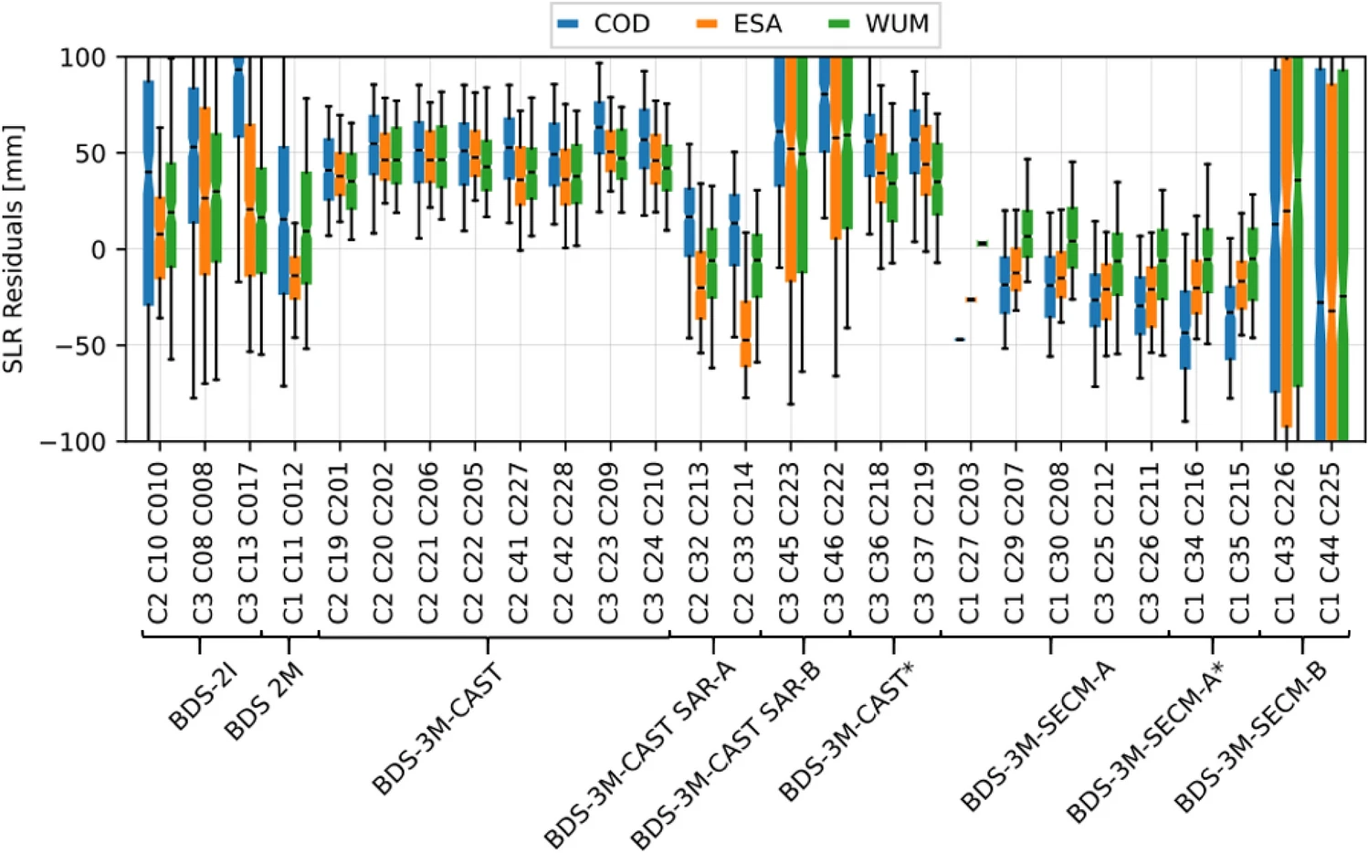
Our research has uncovered additional groups of satellites within the BDS-3 constellation that were not previously identified, pointing to specific challenges in accurately modeling their orbits. We found that 14 of the 24 BeiDou-3 Medium Earth Orbit (MEO) satellites have a standard deviation of the laser range measurements of 19–20 mm, a figure that meets the high standards set by the best Galileo orbit solutions. However, not all the satellites show this level of precision. Our analysis revealed certain groups of BeiDou-3 satellites with significantly worse alignment in laser observations, where standard deviations exceeded 100 mm (see Figure). These findings highlight ongoing challenges and the urgent need for enhanced orbit modeling techniques to improve the reliability and functionality of all BDS-3 satellites.

For more details please read:
Zajdel, R., Nowak, A. & Sośnica, K. Satellite laser ranging to BeiDou-3 satellites: initial performance and contribution to orbit model improvement. GPS Solut 28, 100 (2024). https://doi.org/10.1007/s10291-024-01638-2 LINK
Our team at the Associated ILRS Analysis Center has detailed these advancements in a new study, "Satellite Laser Ranging to BeiDou-3 Satellites: Initial Performance and Contribution to Orbit Model Improvement" by Zajdel et al., 2024. You can read more about the study here: GPS Solutions, Volume 28, 100 (2024). LINK
The BeiDou-3 satellites are equipped with advanced GNSS technology that is set to greatly enhance areas such as geodesy, Earth sciences, and navigation. Despite these advancements, determining precise orbital paths remains a challenge, as different scientific groups often find inaccuracies that could compromise the satellites reliability. To address this, Satellite Laser Ranging (SLR) has become an essential tool. SLR uses laser beams to measure the distance between satellites and ground stations, providing critical external validation of orbit products as determined by different groups. Although these BeiDou-3 satellites have been in orbit for several years, laser tracking only started in February 2023.
Our research has uncovered additional groups of satellites within the BDS-3 constellation that were not previously identified, pointing to specific challenges in accurately modeling their orbits. We found that 14 of the 24 BeiDou-3 Medium Earth Orbit (MEO) satellites have a standard deviation of the laser range measurements of 19–20 mm, a figure that meets the high standards set by the best Galileo orbit solutions. However, not all the satellites show this level of precision. Our analysis revealed certain groups of BeiDou-3 satellites with significantly worse alignment in laser observations, where standard deviations exceeded 100 mm (see Figure). These findings highlight ongoing challenges and the urgent need for enhanced orbit modeling techniques to improve the reliability and functionality of all BDS-3 satellites.

For more details please read:
Zajdel, R., Nowak, A. & Sośnica, K. Satellite laser ranging to BeiDou-3 satellites: initial performance and contribution to orbit model improvement. GPS Solut 28, 100 (2024). https://doi.org/10.1007/s10291-024-01638-2 LINK
 back
back |
 |
 |
 |
Contact
|
INSTITUTE OF GEODESY AND GEOINFORMATICS
Wroclaw University of Environmental and Life Sciences Grunwaldzka 53 50-357 Wroclaw NIP: 896-000-53-54, REGON: 00000 18 67 Phone +48 71 3205617 Fax +48 71 3205617 e-mail: igig@upwr.edu.pl |