News
GNSS remote sensing - how to increase the quality of numerical weather models
15-11-2024
Understanding atmospheric conditions is one of the fundamental steps in creating accurate weather forecasts. However, the relatively limited number of ground-based measuring instruments significantly hampers this task, leading to a reliance on weather models that are not always precise. GNSS satellite techniques are increasingly being used as an alternative to classical meteorological instruments, due to the vulnerability of electromagnetic waves to varying atmospheric parameters, including water vapor. One of the most widely used to ols for monitoring the state of the atmosphere with GNSS observations is GNSS tomography.
However, the classical tomography process, which relies solely on ground-based GNSS observations, faces challenges due to the lack of receivers in sparsely populated areas, such as marine and mountainous regions. The relatively uniform geometry of these observations can cause mathematical problems and lead to instability in the solution.
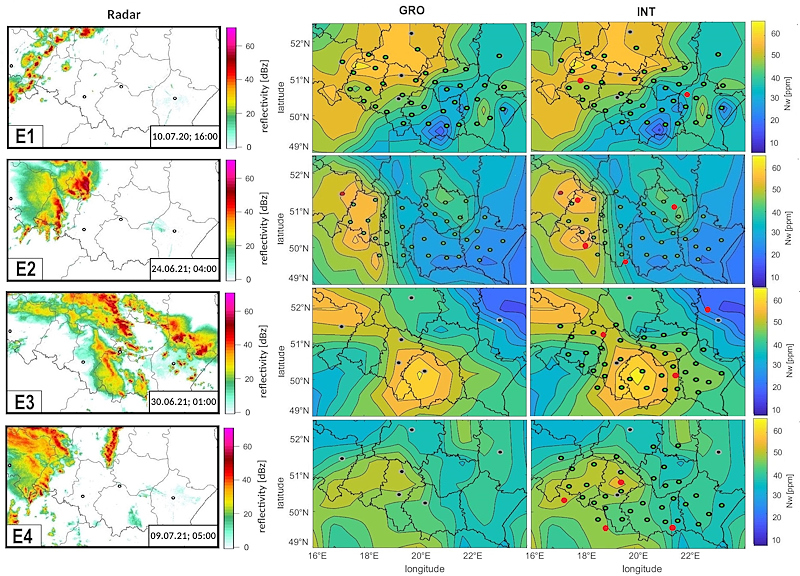
To address both issues, this study represents the first attempt in the literature to integrate ground-based GNSS observations with ground infrastructure-independent radio occultation (RO) observations in a single tomographic model. By employing an innovative method of estimating measurement uncertainties for these two different types of observations, along with a highly accurate ray-tracing algorithm, a series of experiments was conducted to compare the integrated and classical tomographic solutions.
The results confirmed the effectiveness of the integrated tomographic approach, showing a decrease in the root mean squared error by 5% to 30% compared to the classical method. The incorporation of RO also led to a reduction in the uncertainty of the tomographic solution by nearly 5%
For more information about the methodology used and detailed results of this work, please refer to the following articles:
1. Cegla, A., Moeller, G., Rohm, W., Kryza, M., & Taszarek, M. (2024). Application of integrated GNSS tomography in observation study over the area of southern Poland. Advances in Space Research, 74 (8), 3654-3667. https://doi.org/10.1016/j.asr.2024.07.059.
2. Cegla, A., Moeller, G., Hordyniec, P. et al. INTOMO operator for GNSS multi-source tomography based on 3D ray tracing technique. J. Geod 98, 101 (2024). https://doi.org/10.1007/s00190-024-01915-5.

Figure 1: Wet refractivity map for four precipitation periods. The left column displays the precipitation areas and radar reflectivity values. The middle column presents the wet refractivity values obtained from the classical tomographic solution. The right column presents the wet refractivity values derived from the integrated tomographic solution.
However, the classical tomography process, which relies solely on ground-based GNSS observations, faces challenges due to the lack of receivers in sparsely populated areas, such as marine and mountainous regions. The relatively uniform geometry of these observations can cause mathematical problems and lead to instability in the solution.
To address both issues, this study represents the first attempt in the literature to integrate ground-based GNSS observations with ground infrastructure-independent radio occultation (RO) observations in a single tomographic model. By employing an innovative method of estimating measurement uncertainties for these two different types of observations, along with a highly accurate ray-tracing algorithm, a series of experiments was conducted to compare the integrated and classical tomographic solutions.
The results confirmed the effectiveness of the integrated tomographic approach, showing a decrease in the root mean squared error by 5% to 30% compared to the classical method. The incorporation of RO also led to a reduction in the uncertainty of the tomographic solution by nearly 5%
For more information about the methodology used and detailed results of this work, please refer to the following articles:
1. Cegla, A., Moeller, G., Rohm, W., Kryza, M., & Taszarek, M. (2024). Application of integrated GNSS tomography in observation study over the area of southern Poland. Advances in Space Research, 74 (8), 3654-3667. https://doi.org/10.1016/j.asr.2024.07.059.
2. Cegla, A., Moeller, G., Hordyniec, P. et al. INTOMO operator for GNSS multi-source tomography based on 3D ray tracing technique. J. Geod 98, 101 (2024). https://doi.org/10.1007/s00190-024-01915-5.

 back
back |
 |
 |
 |
Contact
|
INSTITUTE OF GEODESY AND GEOINFORMATICS
Wroclaw University of Environmental and Life Sciences Grunwaldzka 53 50-357 Wroclaw NIP: 896-000-53-54, REGON: 00000 18 67 Phone +48 71 3205617 Fax +48 71 3205617 e-mail: igig@upwr.edu.pl |