News
Demonstration Product - Ground Displacement Map for the Upper Silesian Coal Basin Area Now Available on NSIS!
11-04-2025
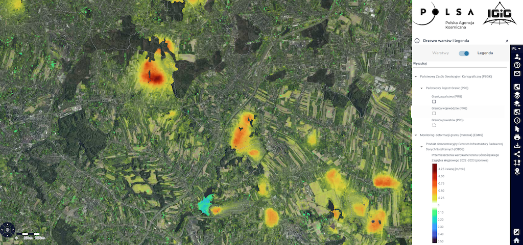
The integrated product developed within the Satellite Data Research Infrastructure Center (CIBDS) based on radar data, presenting ground displacement maps, is now available on the National Satellite Information System (NSIS) portal (https://nsisplatforma.polsa.gov.pl/aktualnosci/cibds_gzw). Previously available in the UPWr Knowledge Base, this product integrates data from the European Ground Motion Service (EGMS) with CIBDS’s DInSAR processing results for the Upper Silesian Coal Basin area, offering detailed ground displacement maps with higher resolution than the products previously available on NSIS.
The product is available on the NSIS portal in the Crisis Management map composition (https://nsisplatforma.polsa.gov.pl/portal?compositionId=395).
As a reminder, the original data can be downloaded for free HERE.
Additionally, the full report, which details the methodology of the product development and the
algorithms used by CIBDS, is available HERE.
 back
back |
 |
 |
 |
Contact
|
INSTITUTE OF GEODESY AND GEOINFORMATICS
Wroclaw University of Environmental and Life Sciences Grunwaldzka 53 50-357 Wroclaw NIP: 896-000-53-54, REGON: 00000 18 67 Phone +48 71 3205617 Fax +48 71 3205617 e-mail: igig@upwr.edu.pl |