News
Tracking the Earths Motion: A Seismogeodetic Experiment in Romania with IGiG UPWr Researchers
30-10-2025
How precisely can an earthquake be measured? Between October 20 and 24, 2025, a team of scientists from the Institute of Geodesy and Geoinformatics at the Wrocław University of Environmental and Life Sciences took part in a unique seismogeodetic experiment at the Seismological Observatory in Timișoara, Romania. The UPWr researchers tested advanced GNSS technologies under simulated earthquake conditions as part of the European project TRANSFORM² (Toward Advanced Multidisciplinary Fault Observatory Systems²), which aims to develop a new generation of seismic activity monitoring systems.
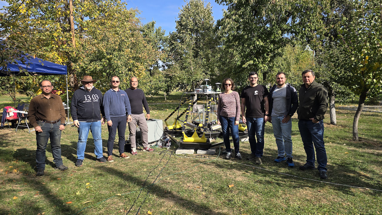
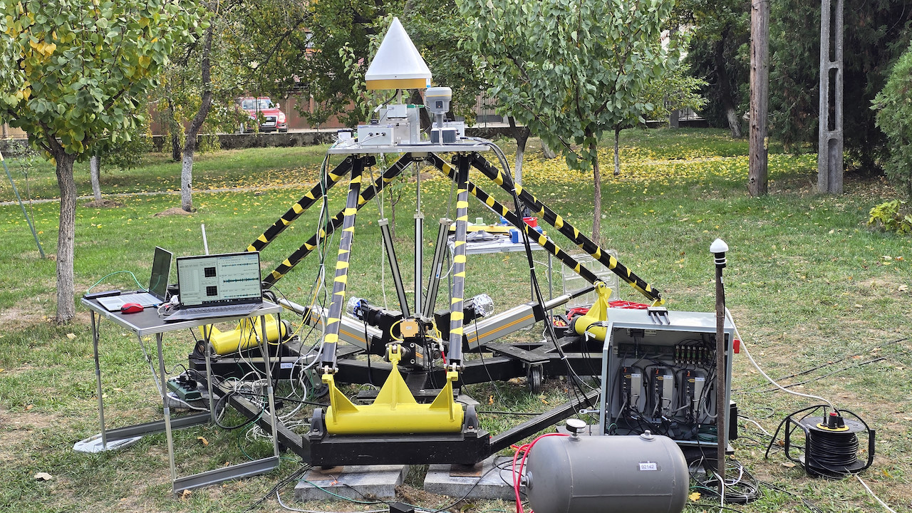
During several days of testing on the ANCO R-303 three-axis seismic table, realistic ground motions corresponding to both real and simulated earthquakes were reproduced. The experiment brought together researchers from Romania, Poland, Greece and Italy, combining expertise in geodesy and seismology.
The IGiG UPWr team - Dr. hab. Eng. Jan Kapłon, Prof. UPWr, Dr. Eng. Iwona Kudłacik, and Dr. Eng. Adrian Kaczmarek - was responsible for designing the experiment, configuring the GNSS equipment, and recording data. The UPWr group provided both geodetic-grade and low-cost GNSS receivers, a component enabling synchronization with an external atomic clock for exceptional measurement precision, as well as other sensors used in the tests.
During the experiment, GNSS antennas (geodetic-grade and low-cost), accelerometers, and inclinometers were mounted on the seismic table in various configurations to test their sensitivity to vibrations resembling real earthquakes. The researchers also carried out real-time data streaming and processing throughout the experiment.
The experiment involved researchers from the following institutions:
The experiment represents an important step forward in the development of modern methods for real-time monitoring of ground deformation and vibrations. The results will contribute to the creation of more precise and cost-effective earthquake early warning systems, as well as to strengthening infrastructure resilience to seismic hazards.
As an outcome of the experiment, a GNSS measurement dataset-together with reference data from seismic sensors - will be published, enabling the international scientific community to comprehensively evaluate the potential of GNSS satellite measurements for seismology and structural monitoring in near-real-time applications.
The TRANSFORM² project is funded by the European Union under the HORIZON-INFRA-2024-DEV-01-01 program and brings together partners from across Europe to modernize and integrate networks of Near Fault Observatories (NFOs), located in regions with high seismic risk.
More information about the project: https://www.linkedin.com/showcase/transform2-project/ i https://www.transform2-project.eu/
During several days of testing on the ANCO R-303 three-axis seismic table, realistic ground motions corresponding to both real and simulated earthquakes were reproduced. The experiment brought together researchers from Romania, Poland, Greece and Italy, combining expertise in geodesy and seismology.
The IGiG UPWr team - Dr. hab. Eng. Jan Kapłon, Prof. UPWr, Dr. Eng. Iwona Kudłacik, and Dr. Eng. Adrian Kaczmarek - was responsible for designing the experiment, configuring the GNSS equipment, and recording data. The UPWr group provided both geodetic-grade and low-cost GNSS receivers, a component enabling synchronization with an external atomic clock for exceptional measurement precision, as well as other sensors used in the tests.
During the experiment, GNSS antennas (geodetic-grade and low-cost), accelerometers, and inclinometers were mounted on the seismic table in various configurations to test their sensitivity to vibrations resembling real earthquakes. The researchers also carried out real-time data streaming and processing throughout the experiment.
The experiment involved researchers from the following institutions:
- National Institute for Earth Physics (NIEP, Romania) - hosts of the experiment, operators of the seismic table, responsible for its operation, configuration, provision of multisensory equipment, and co-design of the experiment;
- Wrocław University of Environmental and Life Sciences (UPWr, Poland) - the UPWr team, co-author of the experimental concept, responsible for configuring the GNSS equipment and providing part of the measurement apparatus;
- University of Patras (Greece) - supplier of GNSS equipment and contributor to the development of the experimental framework;
- Istituto Nazionale di Oceanografia e di Geofisica Sperimentale (OGS, Italy) - participating remotely, provider of a proprietary GNSS receiver.
The experiment represents an important step forward in the development of modern methods for real-time monitoring of ground deformation and vibrations. The results will contribute to the creation of more precise and cost-effective earthquake early warning systems, as well as to strengthening infrastructure resilience to seismic hazards.
As an outcome of the experiment, a GNSS measurement dataset-together with reference data from seismic sensors - will be published, enabling the international scientific community to comprehensively evaluate the potential of GNSS satellite measurements for seismology and structural monitoring in near-real-time applications.
The TRANSFORM² project is funded by the European Union under the HORIZON-INFRA-2024-DEV-01-01 program and brings together partners from across Europe to modernize and integrate networks of Near Fault Observatories (NFOs), located in regions with high seismic risk.
More information about the project: https://www.linkedin.com/showcase/transform2-project/ i https://www.transform2-project.eu/
 back
back |
 |
 |
 |
Contact
|
INSTITUTE OF GEODESY AND GEOINFORMATICS
Wroclaw University of Environmental and Life Sciences Grunwaldzka 53 50-357 Wroclaw NIP: 896-000-53-54, REGON: 00000 18 67 Phone +48 71 3205617 Fax +48 71 3205617 e-mail: igig@upwr.edu.pl |