News
Scientists from UPWr and ESA have solved Einstein’s puzzle resulting from general relativity
28-03-2021

Although Einstein’s general theory of relativity is over 100 years old, it still contains a plethora of as yet undescribed phenomena. Scientists from the Institute of Geodesy and Geoinformatics (IGG UPWr) together with representatives of the European Space Agency (ESA) have published an article that comprehensively describes what happens with artificial satellites orbiting the Earth and how the theory of general relativity affects the orbits of satellites. The authors discovered some unexpected effects and predictions that have never been described in the literature before. Prof. Krzysztof Sośnica presented results from this study in October 2020 and in March 2021 at the meeting of the GNSS Scientific Advisory Committee of the European Space Agency (GSAC) as part of a special invited paper, which triggered a heated discussion. Now, these results have been published in Celestial Mechanics and Dynamical Astronomy by Springer Nature.
 more...
Prof. Andrzej Borkowski, Director of the Institute of Geodesy and Geoinformatics, passed away
13-03-2021
After a long struggle with a serious illness, Prof. Andrzej Borkowski, Director of the Institute of Geodesy and Geoinformatics, passed away 13.03.2021 at the age of 61.
He was a member of the UPWr Senate, a member of the International Association of Geodesy and the Geodesy Committee of the Polish Academy of Sciences, a correspondent member of the German Commission of Geodesy at the Bavarian Academy of Sciences. He was our colleague, friend and mentor.
He was the supervisor of 9 doctoral dissertations, author or co-author of 220 scientific articles and conference reports, a person endowed with outstanding mathematical talent and an unusual sense of humor. A person who is absolutely honest and devoted to scientific work.

Integrated movement science - new research field
05-03-2021

An international group of scientists, including researchers from the SpaceOs Wroclaw University of Environmental and Life Sciences, lead by Dr. Urška Demšar from the University of St Andrews, published an article in the International Journal of Geographical Information Science entitled "Establishing the integrated science of movement: bringing together concepts and methods from animal and human movement analysis" . The aim of the paper is to unify the two fields of science - human and animal mobility analysis, identifying similarities and differences between them.
 more...
IGG and SpaceOs seminars shedule for summer semester 2021 is ready
01-03-2021
Institute of Geodesy and Geoinformatics and Leading Research Group SpaceOs, cordially invites to our summer semester seminar series. Events will be held on selected Wednesdays 1PM (Warsaw time) using Google Meet platform.
Detailed programme can be found below (with respective links to the meetings):
 more...
Detailed programme can be found below (with respective links to the meetings):
 more...
Scientists from IGG determined the high-frequency motion of the Earth pole on the basis of observations from 80 GNSS satellites and 100 ground stations
02-01-2021

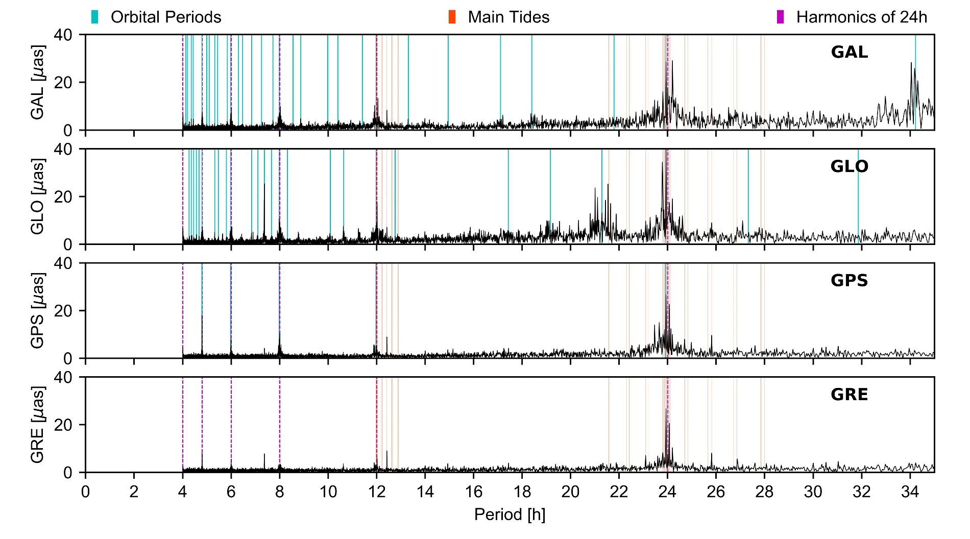
Scientists from the Institute of Geodesy and Geoinformatics, UPWr and the Astronomical Institute of the University of Bern in Switzerland have proven that GNSS observations from GPS, GLONASS and Galileo satellites are able to provide high-quality information on high-frequency changes in the Earth rotation with periods from several to several hours. Therefore, for the first time it was possible to determine the model of the sub-daily Earth polar motion using as many as 80 satellites: GPS, GLONASS and Galileo. All previous determinations of the empirical GNSS models were based on the GPS system, which caused problems due to exactly 2 revolutions of GPS satellites per day, translating into the risk of recognizing orbital errors of GPS satellites as pole movements.
A new method of integrating GNSS data from satellites with different revolution periods allows the development of independent empirical models describing changes in the Earth rotation caused by ocean tides. The very first model of sub-diurnal changes in the movement of the Earth pole which is free from most of the disadvantages of solutions based solely on the GPS system is now described by Zajdel et al. (2021). The model is based on 3 years of continuous observations from 100 ground GNSS stations located on all continents and recording data from 80 GNSS satellites.
 more...
Archive: « PREVIOUS PAGE | 1 | 2 | 3 | 4 | 5 | 6 | 7 | 8 | 9 | 10 | 11 | 12 | 13 | 14 | 15 | 16 | 17 | 18 | 19 | 20 | 21 | 22 | 23 | 24 | 25 | 26 | 27 | 28 | 29 | 30 | NEXT PAGE »
 |
 |
 |
 |
Contact
|
INSTITUTE OF GEODESY AND GEOINFORMATICS
Wroclaw University of Environmental and Life Sciences Grunwaldzka 53 50-357 Wroclaw NIP: 896-000-53-54, REGON: 00000 18 67 Phone +48 71 3205617 Fax +48 71 3205617 e-mail: igig@upwr.edu.pl |