News
AGILE in Vilnius - CAMA Workshop - call for abstracts
30-03-2022

(https://agile-online.org/index.php/conference-2022/home-2022).
 more...
OPENSENSE COST Action – Call for Conference Grant Applications
14-03-2022

IGiG team members (Dr Tomasz Hadaś, Dr Jan Kapłon, MSc Estera Trzcina) have joined a EU COST Action OPENSENSE No. CA20136 "Opportunistic precipitation sensing network" for a period 2021-2025. The action aims to establish a network of opportunistic precipitation sensors (OS) and to lead coordinated activities to deepen and promote knowledge about the use of OS in determining the location and intensity of the precipitation.
 more...
War against Ukraine
24-02-2022
We were all deeply moved by the news of the beginning of the Russian military attack against Ukraine. We hoped that the conflict could be resolved peacefully. Unfortunately, the incomprehensible policy of direct military aggression prevailed. We support the Ukrainians who are fighting to defend their homeland and at the same time, we think with concern and anxiety about our partners from Lviv Polytechnic, with whom we have been working for many years. We continue to believe in a quick end to the fighting and stand in solidarity with the entire Ukrainian people in these difficult times.
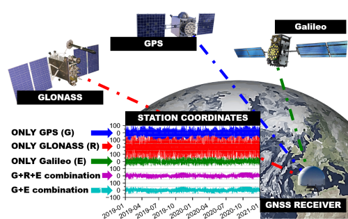
Artificial signals in GPS, GLONASS and Galileo series explained by the UPWr scientists!
14-02-2022

Global Navigation Satellite Systems (GNSS) are widely used for the monitoring of phenomena occurring on the planet Earth. For this purpose, we usually use observations of changes in the position of ground receivers, determined by observations of navigation satellites. The American GNSS system, called Global Positioning System (GPS), plays a key role and is continuously used most often by users. However, the observed temporal changes in the coordinates of ground stations obtained using GPS observations are the resultant of real natural phenomena, anthropogenic processes, and systematic errors of the GPS system. This raises the question of how to separate the errors of the GPS technique from the changes we actually want to observe, such as station displacements caused by ocean tides?
 more...
UPWr with some of the best diploma theses in space fields
23-12-2021
On December 20th in Cracow the second part of Earth Observation Forum devoted to the subject of satellite data used in public administration took place. During the conference results of the Competition for the Award of the President of Polish Space Agency POLSA for the best thesis in the field of space research were announced. From the Wroclaw University of Environmental and Life Sciences 6 theses had participated, which, according to statistics of the agency, allowed our University to take the first place in terms of the number of submitted works. The submitted thesis by our students were of a very high standard, as evidenced by the fact that four out of six sent applications made it to the final part of the competition.
 more...
Archive: « PREVIOUS PAGE | 1 | 2 | 3 | 4 | 5 | 6 | 7 | 8 | 9 | 10 | 11 | 12 | 13 | 14 | 15 | 16 | 17 | 18 | 19 | 20 | 21 | 22 | 23 | 24 | 25 | 26 | 27 | 28 | 29 | 30 | 31 | NEXT PAGE »
 |
 |
 |
 |
Contact
|
INSTITUTE OF GEODESY AND GEOINFORMATICS
Wroclaw University of Environmental and Life Sciences Grunwaldzka 53 50-357 Wroclaw NIP: 896-000-53-54, REGON: 00000 18 67 Phone +48 71 3205617 Fax +48 71 3205617 e-mail: igig@upwr.edu.pl |