News
IGiG Scientific Seminar - Dr. Guohao Zhang
16-04-2026
 The Institute of Geodesy and Geoinformatics kindly invites you to a scientific seminar entitled "Advancing GNSS in Challenging Environments: From Intelligent Positioning to Ubiquitous Sensing", to be delivered by Dr. Guohao Zhang, Department of Aeronautical and Aviation Engineering, The Hong Kong Polytechnic University. The seminar will take place in the IGiG library, room 100G, on 27 April 2026 (Monday) at 9:30 a.m.
The abstract and the speakers biographical note.
Geoid or GNSS processing method? What determines the accurate determination of mountain peak heights?
24-02-2026
The height of mountain peaks can be determined using precise GNSS measurements. However, it should be remembered that GNSS gives the height relative to the ellipsoid – a mathematical reference surface – and not directly above sea level. To obtain the actual height above sea level, it is necessary to use a geoid model, which describes the physical surface corresponding to the average sea level. In addition, there are several methods available for processing GNSS data. So what has a greater impact on the accurate height determination in the mountains – the geoid model or the method of processing GNSS measurements? The answer to this question is presented in the latest article published in GPS Solutions.
 more...
Institute of Geodesy and Geoinformatics participates in the prestigious international FlexPED project
19-02-2026
 We are pleased to announce that a new international research project FlexPED – Energy Data and Flexibility Management for Positive Energy Districts, has been launched at the Institute of Geodesy and Geoinformatics. It is one of 47 projects recommended for funding in DUT Call 2024. The project will be implemented between 2026 and 2028. The Polish consortium is led by Dr. Pawel Boguslawski, professor at Wroclaw University of Environmental and Life Sciences. more...
GNSS tomography-based monitoring of hailstorm events
04-02-2026
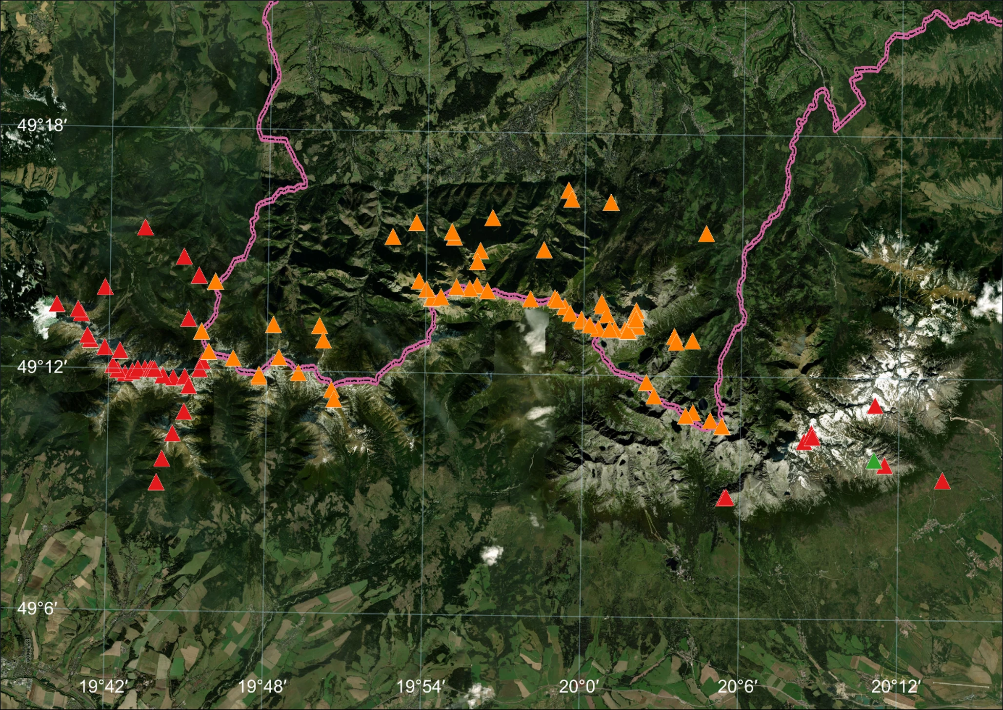
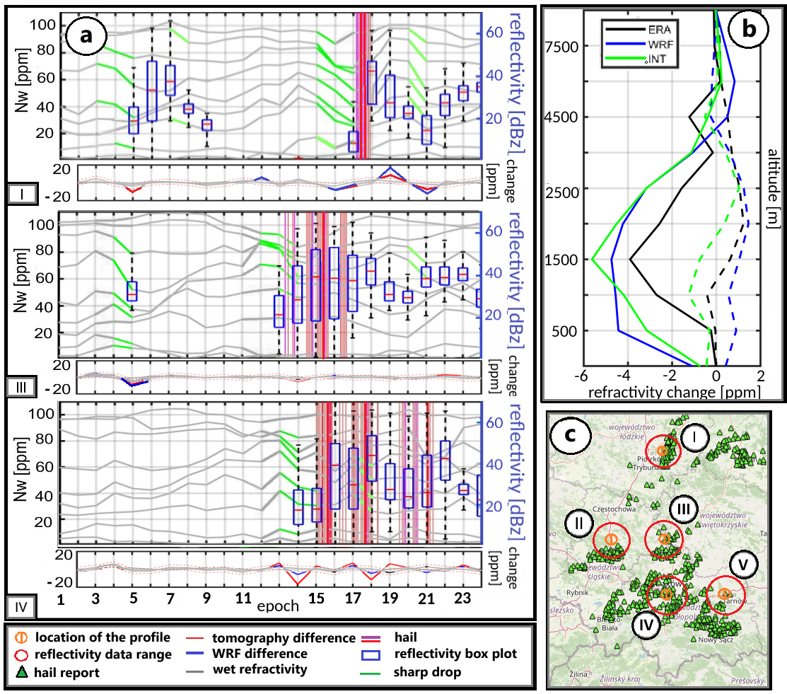 Monitoring convective phenomena, such as heavy rainfall and hailstorms, is crucial for improving our understanding of processes occurring in the troposphere and for enhancing short-term weather forecasts. Traditional observational techniques, including radiosondes, often lack sufficient temporal and spatial resolution to effectively capture the rapid and localized changes that precede severe storms. One response to these limitations is the application of integrated GNSS tomography, which combines ground-based GNSS observations with radio occultation (RO) data. more...
Lecture by Michele Crosetto (CTTC)
27-01-2026
The Institute of Geodesy and Geoinformatics invites to a lecture by Michele Crosetto (CTTC) entitled "Remote sensing research activities at CTTC” (https://www.cttc.cat/geomatics-gm/). The lecture will take place in the lecture room IM, building C2, on 28 January 2026 (Wednesday) at 10:30. The lecture will take the form of a working meeting, during which we will also present our research activities at IGiG so that we can get to know each other better. All interested are welcome.
Archive: « PREVIOUS PAGE | 1 | 2 | 3 | 4 | 5 | 6 | 7 | 8 | 9 | 10 | 11 | 12 | 13 | 14 | 15 | 16 | 17 | 18 | 19 | 20 | 21 | 22 | 23 | 24 | 25 | 26 | 27 | 28 | 29 | 30 | 31 | 32 | NEXT PAGE »
 |
 |
 |
 |
Contact
|
INSTITUTE OF GEODESY AND GEOINFORMATICS
Wroclaw University of Environmental and Life Sciences Grunwaldzka 53 50-357 Wroclaw NIP: 896-000-53-54, REGON: 00000 18 67 Phone +48 71 3205617 Fax +48 71 3205617 e-mail: igig@upwr.edu.pl |